Itinerary: 34 Days, 6 nights hotels, 27 nights camping
26 days trekking, Max altitude – 5600 metres
Day 1 Arrive Islamabad
Arrive at Benazir International airport Islamabad, and met by KKE representative. In Islamabad we use a centrally situated, air conditioned, tourist class hotel. You may want to rest in the morning before lunch, during which a full trek briefing will be held and any questions answered. It may be necessary for the whole group to visit the offices of the Ministry of Tourism to receive an official ‘briefing’ about visiting the restricted area around K2 whilst our agent completes the permit formalities.Depending on the time available to us there may be the option to do some sightseeing in Islamabad, a city purpose-built in 1961 as the new capital of Pakistan.
Alternatively, we could visit the ‘Twin City’ of Rawalpindi a town from the days of the British Raj. The two cities are very different in character; the older settlement is rather sprawling with enormous and complicated bazaars where you can easily get fascinatingly lost. Islamabad, by contrast, is much more open, with many parks and wide streets arranged on a grid system. Overnight Envoy Continental Hotel.
Day 2/3 Fly to Skardu
We take the early morning 1-hour flight from Islamabad to Skardu, skirting breathtakingly past the Rupal and Diamir faces of Nanga Parbat. It is even possible to catch a fleeting glimpse of K2 and the other high peaks of the Baltoro in the distance before landing at Skardu. If poor weather has grounded the Skardu flight we will be obliged to make the journey by way of a 24-hour drive. This is an epic journey along one of the most remarkable roads in the world travelling through the gorges of the Indus River. Overnight PTDC/Concordia Motel.
Day 4 Drive to Hushe
Beyond Khaplu we cross the Shyok River to begin an entertaining four hour jeep ride up to Hushe, through a number of small and picturesque villages in the lower Hushe Valley. En route we must cross a number of ‘nullahs’ or small river valleys. These nullahs which are fed by meltwaters from the glaciers high above the valley, are often dry in the early morning but can become impassable by the afternoon as the hot sun goes to work. Starting from Khaplu ensures that we should have minimum trouble with these ad-hoc rivers. Hushe is the highest village in the area at 3100 metres and is the last permanent habitation that we will encounter until we reach Hispar Village – more than three weeks away. We set up camp in a field just below the village with the huge bulk of Masherbrum dominating the valley to the north.
Overnight in tents.
Day 5 Acclimatisation around Hushe
A day for acclimatisation and for exploring. One option for today is to trekup into the Honboro Valley on the west side of the Hushe Valley. There is a small summer settlement here where women of the village stay for two months of the year grazing goats and yaks and making cheese. En route we will pass the spring source of the clean water supply which is now piped down into the village. Our path follows the route of the pipeline, with excellent views out over the Hushe Valley. Overnight camping.
Day 6 Trek to Saitcho
A short day of about 4 hours takes us to the idyllic campsite at Saitcho. This camp lies at the junction of the Charakusa and Gondogoro valleys and is sited on a sandy, tree-shaded area beside a swift-flowing river. There are excellent views of Nameka, the rock pillars of K7 and from the trail leading to the camp there is a sighting of the impressive Charaksa Spire. Altitude at camp is 3350 metres. Overnight in tents.
Day 7 Trek to Dalsanpa
Heading up alongside the Gondogoro Glacier now, we take a path on a wooded moraine ridge which climbs quite steeply to the seasonal goat-herder’s settlement at Gondogoro Village. Here, we stop for lunch, before dropping down onto the glacier for a scramble along its edge to bypass a section of steep rock. A final scramble up a rocky gulley leads to the very spectacular campsite at Dalsan (4150m) where there are a couple of tiny lakes and staggering views of a range of rocky summits, culminating in the snow-plastered summit of Masherbrum. 5/6 hours walking. Overnight camp.
Day 8 Trek to Khuispan
Dropping down again onto the glacier, our path follows the centre of the ice river, sometimes walking on moraine and sometimes on snow and ice. We get our first views of the Gondoro La at the head of the valley and pass the stunning spire of Layla Peak. A long day, walking beneath the beautiful spire of Layla Peak, takes us to the place called Khuispan (4600m), a grassy terrace beside a small meltwater lake. 5 to 6 hours walking. Overnight camp
Day 9 Rest day/Optional climb Ghondogor Peak
A day for rest and acclimatisation. Together with our porters and trekcrew, we will spend part of this day practicing the safety techniques required for ascending fixed ropes and walking roped on the glacier.(B,L,D). Or optional climb of Ghondogor Peak leaving early morning at 1 am and climb Ghondogoro Peak
Day 10 Trek to Gondoro La basecamp
In preparation for the crossing of the Gondoro La, we will move our basecamp to below the pass on a level site on the lateral moraine of the Gonogoro Glacier at approximately 4800 metres. This is a short walk of just a couple of hours and the remainder of the day is spent in preparation for the crossing. We have an early night for a midnight wake up call. Overnight in Big tent possibly.
Day 11 Cross the Gondoro La to ‘Ali’ camp
A long day, but we are now well-rested and more acclimatised to the altitude. We start out very early to make the best of the snow conditions. The climb to the pass is on steep scree and/or snow, protected by fixed lines and with the final stretch to the pass being slightly more than 45 degrees of steepness. After about 4 or 5 hours our efforts are rewarded by one of the most fantastic panoramic views in the Karakoram. K2, Broad Peak, Chogolisa and the Gasherbrums including the elusive ‘Hidden Peak’, are all laid out before us as we stand at the crest of the pass Descending from the pass presents greater route finding difficulties than the ascent and we must rope up, since there are a number of crevasses and some short sections of steeper snow as we near the Vigne Glacier. It will take us an hour or more to descend from the pass to the West Vigne Glacier, and from here we have a further three hours of roped trekking to our particularly sited camp – the so-called Ali Camp at 4800 metres. We should be in camp by late morning with plenty of time to recuperate after a tiring but thoroughly uplifting day. Around 8 to 10 hours walking. Overnight camping
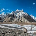
Day 12 Trek to Concordia
From Ali Camp we head straight out onto the Vigne Glacier, and make our way to a junction with the Upper Baltoro. The views of the Gasherbrum’s, Broad Peak, Mustagh Tower and mightiest of all K2, are simply spellbinding as we make our gradual descent to Concordia (4500m). Concordia is not a finite place but the name given to the meeting of three great glaciers. We will make our camp on the stones of the moraine with the pyramid of K2 framed in the Godwin Austin Valley surely one of the best views from a tent anywhere in the world. Overnight Camping.
Day 13 Rest day or trek to K2 Basecamp
For those that wish there is an optional hike to K2 Basecamp, passing close under the flanks of Broad Peak. This is at least a 10 hour round trip and for those who do not wish to make such an extended outing it is well worth visiting the basecamp of Broad Peak which is located halfway from Concordia to K2 Basecamp. This round trip takes around 6 hours. These hikes are optional and those who wish can also take this as a rest day. There are also several options for shorter walks from Concordia.
Day 14 Trek to Gasherbrum BC (5150 m)
Today trek 8/10 hours up the Baltoro gacier to Gasherbrum BC. Gasherbrum is a remote group of high peaks in the Karakorum, located at the northeast end of the 36-mile Baltoro glacier. The group forms a semi-circle around its own South Gasherbrum Glacier. The highest peak is Gasherbrum I. Three of the Gasherbrum massif’s high peaks are over 8,000 meters. Gasherburm I is the world’s eleventh highest peak, Broad Peak is the twelfth highest, and Gasherbrum II is the thirteenth highest. Overnight camping at Gasherbrum BC (5150 m)
Day 15 Trek back to Concordia
Trek back to Concordia. Overnight Camping
Day 16 Trek to Urdukas
Leaving Concordia, we head down the Baltoro Glacier, reaching the camping place at Shachspong (4200m), a name meaning ‘big pile of stones’, at lunchtime. Here, we are in the centre of the glacier, directly below the imposing spire of Masherbrum. During the morning’s walk we have a good view of the shapely summit of the Mustagh Tower on our right and of Masherbrum on our left, or south, side. After lunch, we continue down the glacier, trekking across and around enormous piles of glacial debris, we head for our first off-glacier campsite for some days, at Urdukas (4070m.). This famous camp is sited in the green ablation valley on the south side of the Baltoro Glacier and offers fantastic views of the stunning granite architecture of the Lobsang, Cathedral and Trango groups of peaks, as well as the Uli Biaho Spire. 8 hours trekking. Overnight Camping
Day 17 Trek to Paiju
We continue our descent of the Baltoro, both on the glacier itself and also a trail cut into the valley side. We pass the off-glacier camping place at Horbose and shortly thereafter cut across the glacier to its northern side and descend from the glacier’s snout to the camp at Paiju (3450m). Here, there are the first stunted willow trees that we have seen since the Hushe Valley. 6 hours walking. Overnight Camping
Day 18 Trek to Korophon
Following the Braldu river downstream, we skirt beneath Paiju Peak and follow a sandy and boulder-strewn path beside the Braldu River. Beyond the place known as Chowblok, we reach the tributary Panma Valley and head up-river for half an hour to reach a a bridge which provides the only way of crossing the torrential Panma River. On the other side, the route climbs over a steep spur to rejoin the north bank of the Braldu, which we follow for two hours to the camp at Korophon (3100m.), just before the snout of the Biafo Glacier. 6 to 7 hours walking. Overnight Camping
Day 19 Trek to Mango
We cross the rubble-strewn snout of the Biafo and turn north to follow grazing trails beside this amazing glacier. The path beside the glacier is at first quite demanding as it clings to the valley side, neither truly on the glacier nor quite off it. The moraine-strewn glacier itself gives further tough underfoot conditions and it is with some relief that we climb the lateral moraine to discover a grassy meadow in the ablation valley beyond. This is Namla, a good place to eat our lunch. After lunch, we drop back onto the glacier and follow moraine ridges running up the centre of the glacier. After a good afternoon’s hike, we find a route through the contorted ice to the valley side and climb up to the pleasant green ablation valley at Mango. There are magnificent views across the glacier to the Latok peaks and the Ogre. Altitude at camp is 3626 metres. Overnight Camping
Day 20 Trek to Baintha
Dropping down once again onto the glacier, we cross the jumble boulders to the moraine ridges in the centre of the glacier. Soon we reach the ‘miracle highway’ of white ice which provides easier walking for 2 to 3 hours until we can cross over to the east side of the glacier to make camp at Baintha. This is a splendid camping place, with lush grassland, an abundance of flowers and birds and the chance to spot shy ibex on the mountain slopes above the camp. Altitude at camp is 3940 metres. 5 to 6 hours walking.
Day 21 Rest day
We will certainly take a rest day at Baintha, since the alpine loveliness of this camp is not something to be rushed, bearing in mind that there is absolutely nothing in the way of greenery beyond this point for some considerable distance. This rest stop also allows the porters the opportunity to bake a supply of Balti bread and chapattis to last them over the coming days. There is the very worthwhile option today of ascending a peak above the camp for fantastic views down the glacier and across to the Latok group of mountains and the Ogre. Overnight Camping
Day 22 Trek to Napina
Back onto the glacier, which at this point is over 3 miles wide, on our right-hand side we pass the rocky peaks of the Latoks and Conway’s Ogre, whilst directly ahead of us we can see the rugged spires of the West Biafo Wall, including the ‘fairy tale’ castle of Sosbun Brakk. Here the distances begin to deceive your eyes as the scale of the landscape tests your legs. The walking is at first straightforward, on the ice ‘motorway,’ but as we reach a slight steepening of the glacier the ice becomes more broken and we have to carefully thread a path around numerous crevasses, some small and some enormous. If there is a covering of snow we must rope-up to safeguard our passage over the hidden ‘slots.’ The last off-glacier camp on the Biafo Glacier is at Napina (4215m) 3 to 4 hours. Overnight Camping
Day 23 Trek to Sim Gang
Once more we have to thread our way between crevasses as we approach the southern edge of Snow Lake, with Sosbun Brakk now just off to our left. We make camp beside a mound of rocks at the junction of the Biafo and Sim Gang glaciers. This is the camp known as Sim Gang Basecamp and it is from here that we will cross the southern arm of Snow Lake to the Hispar La. Altitude at camp: 4500 metres. 4 hours walking. Overnight Camping
Day 24 Cross Snow Lake to the Hispar La
An early start for the long traverse across Snow Lake. The ascent to our camp on the Hispar La (5151m) is a fairly gentle climb, but at altitude it will still feel strenuous. This climb is rewarded by one of the most incredible camping places in the world, with views straight down the Hispar to the mountains of Hunza in one direction and back to the Sim Gang Glacier, with its dominant peak the mighty Ogre (7285m), in the other direction. 7 to 8 hours trekking.
Overnight Camping
Day 25 Descend to Khani Basa
We rope up again for the initial descent from the pass on broad snow slopes. After 1½ hours the glacier levels out and we pass beyond the snow line. Continuing down the glacier we have to negotiate a rubble strewn terrain for a further 2 to 3 hours to reach our campsite in a small ablation valley on the east side of the tributary, Kani Basa Glacier, 4 to 5 hours trekking. Overnight Camping 4395 metres.
Day 26 Trek to Jutanmal
Crossing the Kani Basa Glacier allows us fine views toward Kanjut Sar (7760m). After some tricky moraine negotiation we reach a lunch spot at the first water beyond the glacier crossing. There are several outwash streams to cross on the next section of our route and these are best crossed as early as possible in the day. We camp at Jutanmal (4200m). 5 hours walking. Overnight Camping
Day 27 Trek to the Pumari Chhish Glacier
About an hour below camp, we reach the Yutmaru tributary glacier, and this takes a further hour to cross. There are excellent views of Kanjut Sar, Pumari Chhish and Kunjang Chhish from the centre of the glacier. Again, we have lunch at the first available water in the ablation valley beyond the Jutmal Glacier. We camp about twenty minutes’ walk before the next major tributary (the Pumari Chhish Glacier). In 1990, a team of Canadian glacial hydrologists measured the depth of the ice on the glacier at this point to be 500 metres! On this part of our trek, we are generally walking through green meadows with streams, flowers and many birds. Altitude at camp: 4000 metres. 4 to 5 hours trekking. Overnight Camping
Day 28 Trek to Bitanmal
After a short section of difficult moraine, we reach the confluence with the Pumari Chhish Glacier. Excellent views up this tributary, as we cross it. This once difficult crossing is now much easier, the glacier having receded markedly in the past ten years. A very steep path leads through the moraine cliffs at the west side of the glacier, to our lunch spot at the meadow known as Dachigan. We camp at the expansive meadow of Bitenmal where there is a large group of huts, sometimes used by shepherds from Hispar, but usually deserted. Altitude at Bitenmal is 3718 metres. 4 to 5 hours trekking. Overnight Camping
Day 29 Trek to Hispar Village
An early start is essential each morning as we descend the Hispar glacier. This is because the side streams which must be negotiated are much less formidable before the heat of the day (and associated snow-melt) swells them to impassable proportions. After crossing the Kiang Glacier, there is a steep climb to regain the path which leads through the grazing grounds of Daltanas and Falolingkish. One large stream has to be crossed just before Falolingkish, and then a footbridge leads across to Hispar Village. This is a large village by Nagar standards and its cultivated lands stretch for miles along a huge alluvial fan. We will take lunch here and depending upon the state of the road, we may meet our jeeps here or we may have a further hour’s trek to ‘Down Hispar’. We meet our vehicles here and will generally drive for 1 hour to our last campsite which is no less idyllic than the previous. A veritable lawn of grass beside a large pond provides the perfect place to say thank you and goodbye to our Balti and Hunza porters whose jolly company we are sure to remember as much as the spectacular scenery of the past two weeks. Overnight Camping
Day 30 Drive to Karimabad Hunza
We travel by jeep for 2 hours to Nagar and just beyond the village we reach the Hunza. Karimabad is the delightful old capital of the Hunza Kingdom. From Karimabad, with its souvenir shop, post office and tea shop, you can obtain a magnificent view of the valley laid out below you and of the peaks behind. The Aliabad / Karimabad area is sprinkled with wild flowers and blossoming fruit orchards. We will spend half our day in these two towns enjoying the greenery and delighting in the sound of babbling brooks. Overnight at Hunza View Hotel.
Day 31 Visit Baltit Fort and day trip to Duiker (Eagle’s Nest)
After breakfast proceed for visit to historical 800 years Baltit Fort. The people of Hunza are famous for their long lives. After fort we walk back to our hotel through one street Karimabad bazaar where we have a chance to see the handicrafts and local embroidery and to buy souvenirs. After lunch we proceed to Duikar (eagle’s Nest), a summer village was established to supplement the food supply of Altit village, and is habited only from April to October. From the crest of the hill which dominates the village, we have panoramic views of lower Hunza Valley, Nagar Valley, Rakaposhi, Hoper Glacier, Ultar II and Bubliting, amongst others. We return to Karimabad and on the way we also stop at Altit Fort 900 years old Fort before getting back to our hotel. Overnight at Hunza View Hotel.
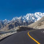
Day 32 Drive to Chilas
Heading south, we pass below Rakaposhi, which at 7788 metres (25,552 feet) is the number 29 in the world rank of highest mountains. Rakaposhi was first climbed in 1958 by
a British expedition which included George Banks and Tom Patey. The glacier spilling down from its flanks reaches almost to the road. We continue down the highway as far as the mountain town of Gilgit and onward to Chilas on the Karakorum Highway. Approximately 5 – 6 hours drive.. Overnight at Shangrila Midway House. (230 Km)
Day 33 Drive to Islamabad
After an early breakfast, we take the drive from Chilas to Islamabad, along the Karakorum Highway. On arrival transfer to Hotel. 10/12 hours (460 Km)
Overnight Envoy Continental Hotel.
Day 34 Depart Islamabad
Transfer to airport for flight to onward destinations.